The first British county maps began to appear in the 1570s and were always created for specific purposes such as recording land holdings or boundaries and, in the case of county maps, to give a representation of the size of the county and perhaps its main towns. Before the Ordnance Survey began to record everything in an area on its maps, county maps were usually not drawn to scale and many of these early examples were a little bit vague in the detail that they provided. Very often a county map was funded by subscription so unless one of the subscribers had paid a generous sum of money to the mapper, a manor or estate might have been omitted entirely. In the case where someone subscribed then their name and coat of arms as well as their manor house might then appear on that map while their neighbours who had not subscribed might be excluded entirely.
Early county maps can be less than accurate, with some of the most significant buildings being shown but not necessarily in the right spot. It was accepted that maps were representative of the area and so if it looked prettier to show a building on the edge of a village or the edge of a field rather than where it actually existed, then the person drawing up the map would do just this.
Often when county maps were rereleased they were added to as time went on. Names of landowners may disappear over time and other people’s names emerge as the new editions were brought out. New buildings would be added to the map depending on who was willing to pay towards funding it. The business of making money out of the publishing of maps was a difficult enterprise and a lot of map makers went bankrupt.
Some of the most well-known early county maps were published by John Speed in his 1611–23 series The Theatre of the Empire of Great Britaine. Many of these can now be found online.
An early county map
One example of a county map was William Faden’s map of Norfolk. Published in 1797, it was the first wide-scale county map to become available. William Faden, a cartographer, engraver and publisher of maps, was appointed as the geographer to King George III and to the Prince of Wales. He began surveying the county in order to create this map between 1790 and 1794. Original copies of the map are rare to find and command many hundreds of pounds when they are put up for sale. There are, however, examples of the map to view for free online, for example: http://www.historic-maps.norfolk.gov.uk/mapimageviewer/
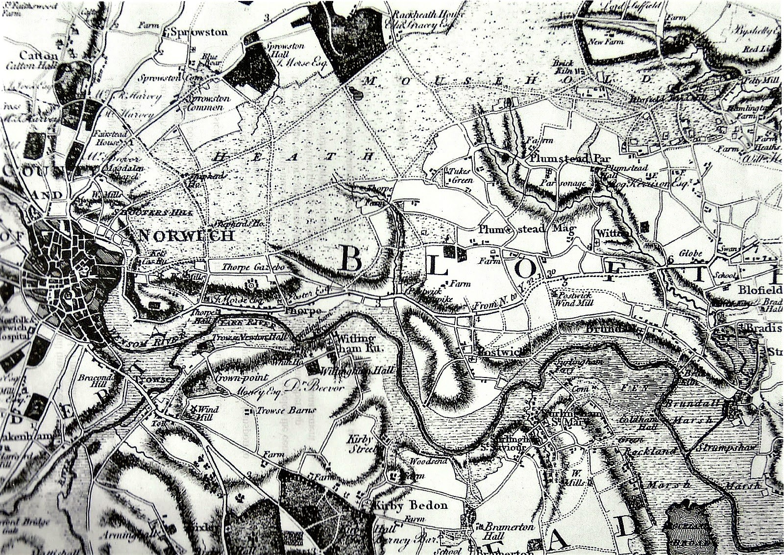
Faden’s original map was produced in six sheets at one-inch to the mile and was often hand-coloured. This county map showed where the estates of landowners were at the time, recording those of both the major as well as the lesser landowners in the county. Faden’s map provides us with a moment in time from the end of the 18th century by capturing the details of the north Norfolk coast, the Broads and fenlands in a period before the many extensive changes of the next 200 years had occurred. It should be said, however, that while Faden included detailed mapping for some of the major towns such as King’s Lynn, Great Yarmouth and Swaffham, his map did include a number of minor errors. He misspelt place names, for example, and some churches are not in their exact correct positions.
Examining the map reveals brick and lime kilns and evidence of agricultural land that had only recently been enclosed and it is possible to see a pattern of settlement adjacent to village commons and parishes that were about to disappear in the years following its publication.
County maps will not show as much detail as that to be found on an Ordnance Survey map, nor that which appears on either a tithe map or an estate map. The early county maps were often attractively illustrated and gave a visual representation, though not necessarily an accurate one, of the boundaries of the administrative region know as a county. County maps can show towns, roads and rivers and estates but relied on funding as explained above.

Collections of county plans, maps and atlases are available at family, house and social history societies, city archives, county record offices, and public and university libraries. See our page on map collections.