Early maps were often produced for a traveller to use as they moved from place to place. The lack of surviving maps from medieval or earlier times may be explained by their destruction from use ‘on the road’ by the merchants and pilgrims for whom they may have been made.
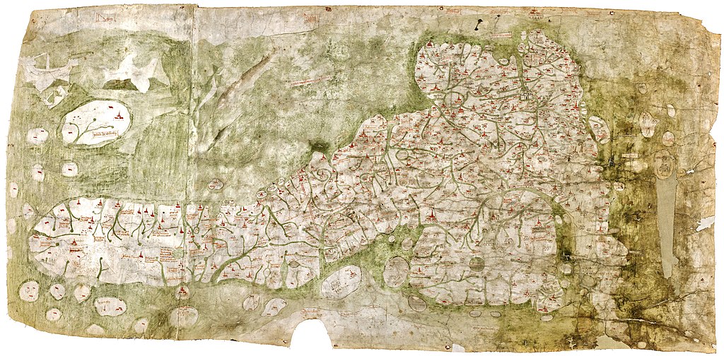
One, however, that did make it through the years is The Gough Map or Bodleian Map and is an example of a late medieval map of the island of Great Britain. The actual dates of its production and authorship are unknown though it was thought it may have been between 1300 and 1430 with different theories as to which precise time period it was actually drawn in. It was named after its one-time owner Richard Gough, who bequeathed the map to the Bodleian Library in 1809. Gough had acquired the map in 1774 from the estate of the antiquarian Thomas ‘Honest Tom’ Martin. There have been various copies of the map made and an interactive online version can be found at http://www.goughmap.org/map/
The Gough Map is important due to its break with previous theologically based mapping. It portrays routes and gives distances from towns and settlements in an unknown unit of measurement which was unusual in British maps before the 17th century.
Towns are featured on the map with gold lettering for the annotation of London and York while other principal settlements are illustrated. A disjointed network of narrow red lines drawn between settlements spreads out across much of England and Wales. Richard Gough had described these lines as ‘roads’, and this belief had held all through the 19th and 20th centuries leading to the document often being referred to as a ‘road map of Britain’. Recent map scholars have now proposed that the lines are routes rather than actual roads and were meant to give a visual representation of the distances between the settlements. Notwithstanding this, it remains the most accurate map of Britain prior to the 16th century.
Historical road maps
A modern road map, sometimes referred to as a route map or even as a street map, is one that shows in a visual form roads and often other transport links rather than the physical geographic features. Its main purpose is to aid the user to navigate from one place to another and will show roads, points of interest and often boundaries of areas. Some road maps will include points of interest, such as prominent buildings, businesses, tourism sites, public parks and recreational facilities, hotels and restaurants, as well as airports and train stations.
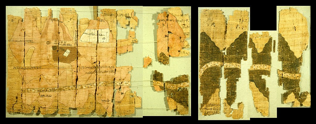
Compare this with the Turin Papyrus Map that is sometimes thought of as the earliest known road map, having been drawn up around 1160 BC. This archaic plan depicts routes along dry river beds through a mining region east of Thebes in Ancient Egypt.
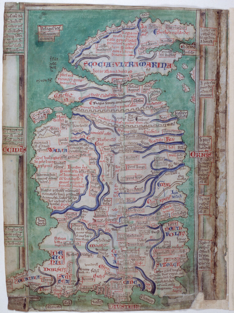
The early road maps of Britain were produced as strip maps showing the route to take from one point to another. The English Benedictine monk Matthew Paris (1200–59), who was a chronicler, artist in illuminated manuscripts and cartographer, was the first person to draw a strip road map showing the route to take from London to Rome. He also drew up four strip maps of Great Britain drawn in the 1250s.
The maps give a unique sense of mid-13th-century Britain. Paris was considered to be the greatest English cartographer of his age, despite not travelling far from his own monastery at St Albans in Hertfordshire. His maps sometimes displayed inaccuracies: in his most detailed depiction of the British Isles, for example, Scotland is joined to the rest of mainland Britain by a bridge situated at Stirling. Other geographical errors included Rochester, Canterbury and Dover being incorrectly located due south of London while Windsor (‘Windleshores’) is depicted as a castle that straddles the River Thames. It is possible to view images from Paris’s maps at https://www.bl.uk/collection-items/matthew-paris-map-of-britain
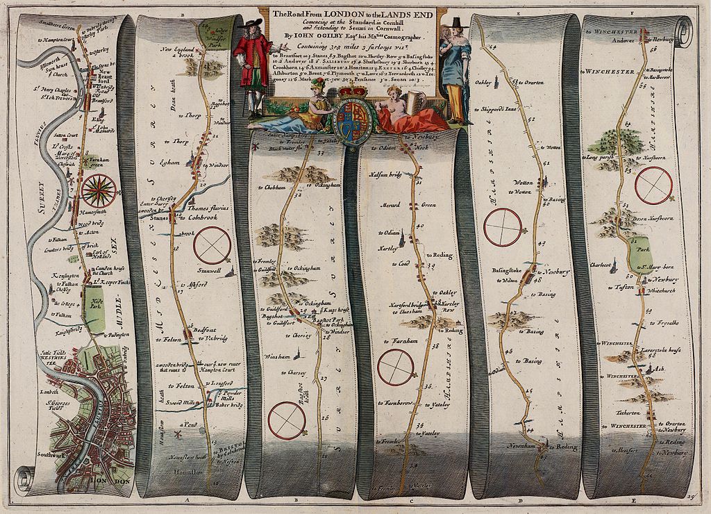
It was down to John Ogilby from Dundee (1600–1676) to take this idea of strip road maps and develop it into a complete set of maps for the mail delivery roads of England and Wales. These he published in Britannia in 1675 as a 300-sheet volume using a map scale of 1 inch to 1 mile. Ogilby dedicated it to King Charles II who had, in the previous year, appointed him as ‘His Majesty’s Cosmographer and Geographick Printer’.
The British Library has put online images from Britannia, volume the first: or, an illustration of the Kingdom of England and Dominion of Wales; by a geographical and historical description of the principal Roads thereof. https://www.bl.uk/collection-items/britannia
More recent road maps
Many researchers will be interested in using old road maps as a way of understanding where an ancestor who had disappeared from the records of one town or area may have gone. When it comes to researching in the British Isles one of the top resources for this are the Ordnance Survey Maps – Six-inch England and Wales, 1842–1952. This series is thought of as the most comprehensive, topographic mapping covering all of England and Wales from the 1840s to the 1950s. Published in two editions for all areas of this part of Britain, they were followed by regular updates during the 20th century for urban or any other rapidly changing areas.
Commercial website TheGenealogist has a powerful mapping tool that applies georeferenced historic and modern map layers linked to various name-rich record sets for family, social or house history researchers. The maps include street and road maps from various periods and it can be seen here: https://www.thegenealogist.co.uk/maps