If you are interested in an ancestor who had once lived in a given parish and want to find out more about a particular property then tithe records and their maps are a very useful resource to use. This is also the case for anyone who is researching local history or is simply seeking a large-scale map of an area in the mid-19th century.
The principal purpose of the tithe maps was to provide visual means of reference to the apportionment schedules compiled by the surveyor at the time. Each piece of land liable to tithes was depicted and given a plot number, unique within that parish, by which it could be identified in the apportionment schedules that contain columns for the names of the landowners and the occupiers. Other columns show the plot numbers and the name (if applicable), description and type of crop of each tithe area as well as noting how much tithe rentcharge (see below) was payable on that tithe area. Before the individual schedules the apportionment books record statistics on the overall extent and state of cultivation of the lands in the tithe district. They also record any lands exempted on various grounds from payment of tithes, such as commons and roads.
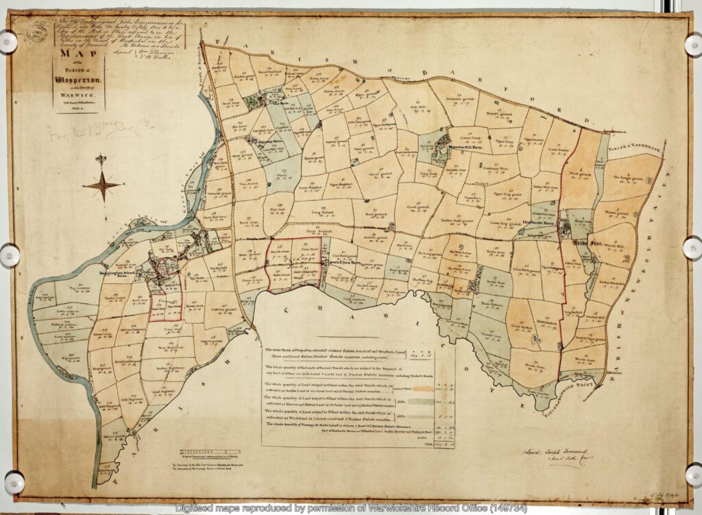
Tithe maps are usually annotated by hand and were frequently from an earlier date than the first Ordnance Survey maps. Tithe maps will often show details such as boundaries, roads, waterways, buildings and woodlands. Sometimes these Victorian-era maps show other details such as hedges, field names, mines and factories.
The tithe survey that generated the tithe maps covered a large part of the country that was still subject to tithes and had not been enclosed. It can be used to discover where people were living and who their neighbours were in the period of the survey from 1836 when the Tithe Commutation Act was passed.
The process of surveying and recording tithe maps took over 15 years. The earliest tithe maps and apportionments that you are likely to find date from 1837 though the peak years for surveying were 1839–1843 with a few still being done in the early 1850s.
The original purpose of tithes was as a tax levied to support the local church and its clergy. The requirement was for one tenth of all agricultural produce to be paid annually to the church, but after the Reformation a good deal of land passed from the Church to lay owners who inherited the entitlement to receive tithes, along with the land. It had become thought of as an outdated practice by the early 19th century and as Britain industrialised and an agricultural depression took hold, the government sought to commute the practice of tithes being paid in kind to instead become a monetary payment called rentcharge. There was also dissent from the growing members of nonconformist religious congregations that objected to having to give tithes to the established Church. It was under these circumstances that the 1836 Tithe Commutation Act abolished tithes in kind converting them to the more convenient monetary payments. To do this, however, required the massive tithe survey to be established in order to find out which areas were subject to tithes, how much was payable and to whom.
Altered apportionments and their maps
You may come across some tithe maps that relate to altered apportionments. This is where a change in ownership and the way land was divided up was subsequently recorded, although sometimes these records and maps were not formally made until several years after the change in ownership. There were many cases where no formal record was actually made; instead an informal and local agreement may have been made between tithe owners and landowners and so no map exists. Some altered apportionments have maps that detail what changes had been made and show the change on an accompanying map. In the case of a number of changes made at different dates you may see a series of numbers used to differentiate the different alterations. Usually letters or some other sign, either in the original apportionment or in subsequent altered apportionments, are recorded. Thus for example, you could see 25, 25a, 25Aa, A25 marked on the record and the map.
The tithe commissioners in London were sent the tithe records and maps for all of the country and it is this set that is in the safekeeping of The National Archives and have been digitised, made searchable and put online by the commercial website TheGenealogist.
To search tithe records online: https://www.thegenealogist.co.uk/search/advanced/landowner/tithe-records/