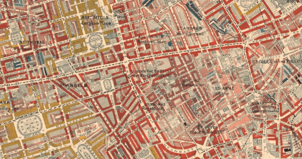
Charles James Booth was a British shipowner, social researcher and reformer who became best known for his philanthropic studies on working-class life in London towards the end of the 19th century. To carry out his landmark survey in the years between 1886 to 1903, Booth created poverty maps to illustrate the conditions of the lives of London’s poorest inhabitants. These maps he based on his observations of contrasts in lifestyle and focused on qualitative factors: food, clothing, shelter, and relative deprivation.
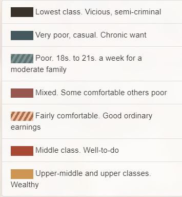
Booth, along with a team of researchers, undertook a survey of every street in London to gauge each household’s class. This was then recorded by assigning the letters A–H to each area, with A–D constituting want, and E-H representing comfort. Booth’s maps colour-coded each street to demonstrate in a visual form the level of poverty or comfort its residents were subject to. The colour-coding was also used to highlight the social conditions of the households on the streets. The objective of these maps was to bring to the attention of Victorian society the social evil of poverty and the problems. The maps revealed to those who analysed them how there were greater concentrations of poverty south of the Thames, compared to the East End slums.
Descriptive Map of London Poverty 1889
The first edition of the poverty maps that was published was based on data collected from School Board visitors. An initial map sheet covering the East End was printed in the first volume of Labour and Life of the People, Volume 1: East London (London: Macmillan, 1889) as the Descriptive Map of East End Poverty.
In 1891 the map was then expanded to cover four sheets that related to an area from Kensington in the west of London to Poplar in the east, as well as stretching from Kentish Town in the north to Stockwell in the south. These were included in subsequent volumes of the survey when they were published and are collectively known as the Descriptive Map of London Poverty 1889 and used for their base the Stanford’s Library Map of London and Suburbs at a scale of 6 inches to 1 mile (1:10560). The original working maps from this first edition of the poverty maps were, however, based on the 1869 Ordnance Survey 1:2500 maps and these hand-coloured maps are now held at the Museum of London.
Maps Descriptive of London Poverty 1898-9
The first edition of the maps had shown Booth that social mapping of this type had sufficient value that he should organise a full revision ten years on from the original survey. Social investigators were sent out to accompany policemen walking their beats across London and then write down their own judgement of each street they saw, also adding the comments of the policemen they were shadowing. Drawing together this information a revised street classification was produced.
Consisting of 12 sheets that covered an area from Hammersmith in the west, across to Greenwich in the east, and from Hampstead in the north down to Clapham in the south this was then published in the survey volumes between 1902 and 1903. The maps for this second revision are collectively known as the Map Descriptive of London Poverty, 1898-9. This used Stanford’s Library Map of London and Suburbs again using a scale of 6 inches to 1 mile (1:10560) as the base. The original working poverty maps that resulted from this second edition are held in the Booth Collection at LSE Library. When published the hand-coloured maps used the newer 1897 Ordnance Survey 1:2500 maps as their base.
Booth’s Poverty maps 1898-1899 can be searched online on the London School of Economics Charles Booth’s London website. Also, they are one of the layers that can be applied in the Map Explorer tool on TheGenealogist family history research site. This interface features modern and historical maps that have been georeferenced to enable researchers to switch between old and new maps in order to better understand where ancestors may have lived, even when the modern terrain is significantly different from the past.